July 11, 2026
100 year old footpath row rumbles on…
PARISH councillors in Staindrop are disappointed that an antique map showing a footpath was put in by the local authority is not being considered by county council officers.
Minutes also show that a dispute over who is responsible for the North Green path’s maintenance has been ongoing for more than a century.
The county council maintains the footpath belongs to Raby Estates and that it is not a public right of way and use of it is merely permissive.
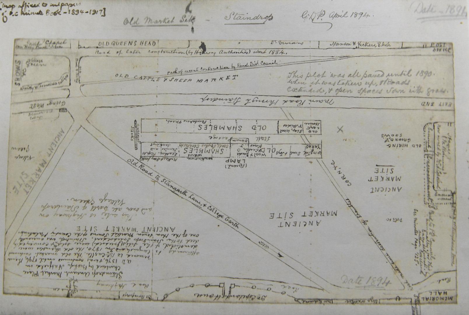
Staindrop Parish Council members, in a meeting in April, poured over a minute book from between 1894 and 1917 which makes several references to the controversial walkway.
A map in the book, dated 1894, indicates it to be a “path of recent construction by Rural District Council” .
Cllr Roger Humphries said: “The Rural District Council was the highway authority then.”
He also referred to minutes from a parish council meeting in the late 1800s which read: “That the attention of Barnard Castle District Highway Board be called to the dilapidated condition of the flat footpath in certain parts of the village of Staindrop and ask the same to be remedied.”
He added that a letter from the clerk of the parish council to the Local Government Board at Whitehall also confirmed that the entire village green, footpaths and the surrounding roadways were being maintained by the Rural District Council.
Cllr Humphries said it should be “screamingly obvious” that Durham County Council, as the local highway authority, should be maintaining the walkway.
At the parish council’s latest meeting members heard that a legal services officer had replied that the information is not needed.
The officer had written: “Officers are working with the landowners to achieve dedication of the footpaths. This is a sensible approach which would achieve the parish council’s objective, without the need for officers to spend considerable time evaluating historic evidence.”
Cllr Humphries pointed out that the definitive map has to be under continuous reviewed by the highway authority.
He added: “One of the events that can allow them to make a change is the discovery by the authority of evidence that a right of way that is not shown in the map and statements, subsists or reasonably alleged to subsist to the area that the map relates.
“I would contend that in 2016 they had 30 pages of evidence that a footpath exists since God knows how when, but was also maintained by the highways authority. A proactive authority would have said ‘hmmm, we’ll have a look at this’, but they haven’t of course.”
Cllr Humphries said the parish council has been waiting for five years for negotiations between Durham County Council and Raby estates to be concluded.