As winter approaches, the Teesdale Mercury’s forecaster Ken Cook reflects on the science and reveals how two men with north-east connections played a part in the way we tell the weather…
Meteorologists believe there is a 75 per cent chance this will turn out to be the hottest year since records began in 1772… and man-made climate change is at least partly to blame. So far this year, the Central England Temperature (CET) from measurements within a triangular area of Lancashire, London and Bristol has been above the long-term average every month except August.
The above is taken from the BBC website. My records go back to the 1960s for the Teesdale area and here we are also looking at possibly the warmest year to date, although 2006 will run it close. Month after month, we are seeing above average temperatures – in the dale they have risen by about half a degree in the past 50 years.
Teesdale’s warmest years are likely to occur with greater frequency than they would without global warming. All parts of the earth warm differently, but current signs and scientific thought are that they will all warm eventually.
The CET was begun by Professor Gordon Manley in the early 1950s. He had a great love of north-east England, especially upper Teesdale and it was a friend of his who described the area as having a climate similar to sea level in Iceland as they walked in the upper dale.
Manley initiated the Moor House and Upper Teesdale Nature Reserve and the weather station on the summit of Great Dun Fell.
A lot of the warming is probably man-made with greenhouse gas emissions, but there are many doubters out there who point to natural variations in the earth’s climate that have always happened. I have spoken to many experts in the Royal Meteorological Society who know far more about climate change than I do and more are coming down on the side of humans influencing a warming world.
Some people blame the sun’s heat output. I spoke to Professor Joanna Haigh from Imperial College and Sir Arnold Wolfendale, ex-Astronomer Royal. Both world-renowned experts in solar output agree that solar-constant heat output has not varied enough to warm our climate as much as this.
Because our average winter temperatures are so close to zero centigrade in the dale, any rise or fall by a few degrees becomes noticeable as the snowline rises and falls accordingly.
Last winter was milder than normal with little snow at habitable levels, but lots of snow on the highest fells. A couple of winters ago, the temperature was a few degrees below normal and the snowline lowered to cover the whole dale for several months.
The slightly lower temperatures of 50 or more years ago would lower the snowline to bring average days of lying snow to lower parts of the dale for longer. It was not snowy every winter and there were variations as now, albeit with slightly lower temperatures. Some periods were very snowy, such as the 1940s, 1950s and 1960s. Some, such as the early 1900s, the 1920s and 1930s, were mild with less snow.
The severe winters we remember tend to be in the Second World War, then 1947, the mid-1950s and particularly 1963 which was the coldest in our dale since 1895, another severe winter.
Summer warming is not as perceptible as winter because it lacks visual evidence of snow and ice. Lengthy severe spells in winter are usually caused by the jetstream shifting, causing a blocking anticyclone to stop the flow of mild Atlantic depressions from the west.
Blocking to our west will bring northerly winds, but the usual severe winter blocking pattern is an anticyclone across Scandinavia which brings easterly winds from the cold interior of Europe and Russia. This happened especially in 1947, 1963 and 1979 and more recently 2010. Most winters, except last year, have at least one week’s blocking with easterlies but the really severe ones keep the blocking going for several months.
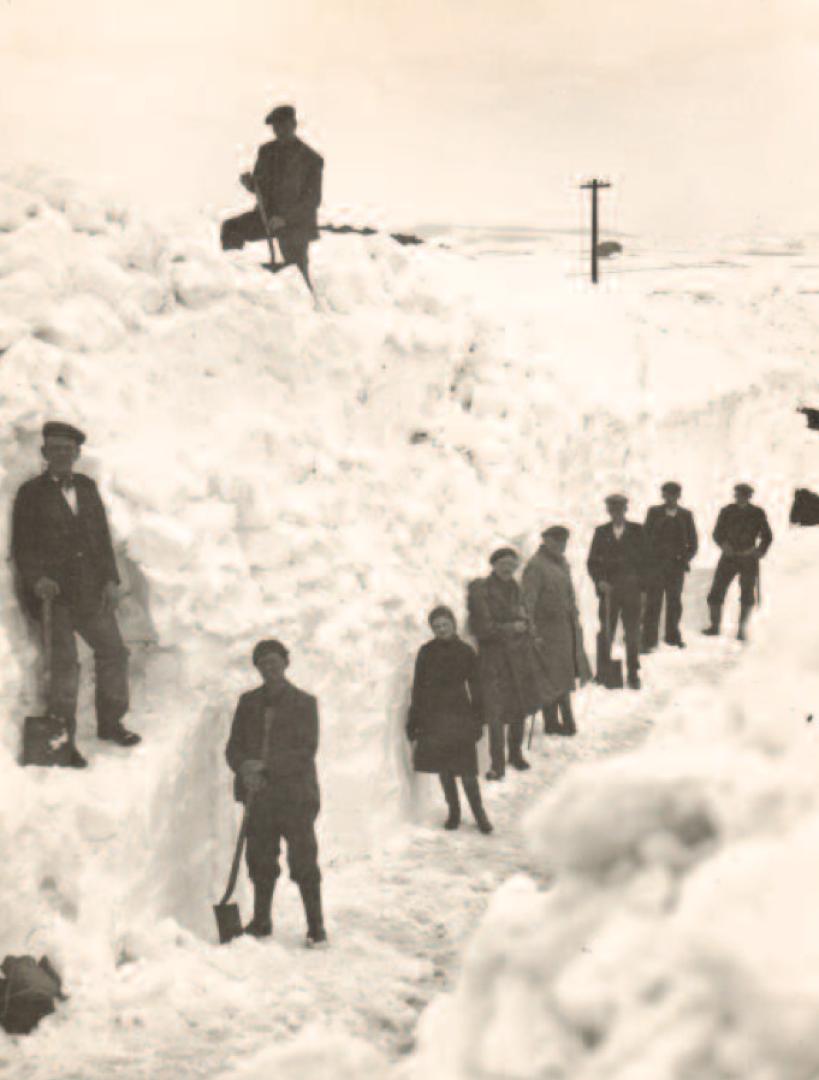
The heaviest snowfalls in the dale happen when milder air pushes up from the south and mixes with the cold air. The winters of 1947 and 1979 brought the heaviest falls as the milder air almost reached us, but not quite. In 1947 snow piled up 83in (211cm) by March at the Forest-in-Teesdale weather station at the Post Office run by the Redfearn sisters. This remains the deepest snow ever measured in England.
In severe winters, if the mild air is far enough south, we have snow showers off the North Sea but not the extended blizzards. Hence 1963 and 2010 were very cold, but did not have the really disruptive snowfalls of 1979 and 1947.
Snow clearing equipment has improved and roads that would have remained closed in the past are now kept open by superior machinery. Public expectation also means roads are cleared more efficiently and regularly.
The winters on the continent do vary but it is that critical closeness to 0C (32F) that is important. Temperatures actually vary more than ours (two degrees centigrade above or below normal is very unusual for us) as we are surrounded by unfrozen seas which temper things.
Moscow, for instance, would need to have an extremely mild winter for no snow as normal winters there are around -10C. The snowline definitely rises and falls in the Alpine regions, and some lower ski resorts have been virtually snow-free some winters.
I have seen evidence of High Force frozen solid in 1963 and 1929, and I am reasonably certain it would have frozen or partly frozen in 1881, 1895, 1940, 1941, 1942, 1945, 1947, 1955, 1956, 1969, 1979, 1986 and 2010.
What is coming this winter? The Met Office long range winter forecast is for it to be close to normal with some colder spells after the new year. Close to normal in mid-Teesdale at 1,000ft (300m) means snow covering more than half the ground for around 40 days and falling on 60 days.
We do not expect it to be as mild and wet as last year, but not exceptionally severe either. Met Office long term forecasts are roughly only 60 per cent accurate and a sudden blip in the jetstream can swiftly change things.
Nobody really knows what will happen beyond, at the most, ten days ahead with current computer power. Meteorology is not an exact science but scientists are improving forecasting accuracy as computer power increases.
In the early 20th century it was realised that mathematics was key to improving weather forecasting. This was by a man with north-east connections: Lewis Fry Richardson, a mathematician from Newcastle. He developed the beginning of numerical computer forecasts that are the cornerstone of modern weather predictions.
Really accurate forecasts for months ahead for one small location in a variable climate like ours will not be available, in my opinion, for many years. A hundred years is a long time though, and it might be possible by then. It would lose a lot of excitement for us, though, if we knew exactly what was coming.
l Ken Cook, a retired headteacher, has lived in the Teesdale/Weardale area since the late 1960s. He has worked as an observer for the Met Office for about 50 years. He reports weekly in the Teesdale Mercury – see his forecast for local weather on P8