Richard Acland, right, takes a closer look at a scenic stretch of the A66 and notes some points of interest
On a fine day, a ride out across the Pennines on the A66 over Stainmore with its sweeping views is an exhilarating experience. This cross-country route is steeped in history and for those who care to look, there are several points of interest.
Starting at Bowes, the snow gates at the edge of the village are evidence that this Pennine crossing can be hazardous in bad weather. There is little point though in doing this journey for pleasure except in good conditions because clear skies and sunshine are essential to see the best of the landscape and scenery.
Look out for the last building on the right hand side of the road, Pasture End Farm is aptly named because beyond there is only wild moorland to the north.
Here the Pennine Way footpath crosses the A66 via a passenger tunnel. Opposite the farmhouse is a small layby flanked by conifers. This is a good place to park in order to descend into the valley to visit God’s Bridge – a natural limestone bridge over the River Greta.
Right next to God’s Bridge there is a cottage on top of an embankment which, on closer inspection, can be seen is the trackbed of part of the Stainmore railway line, which closed in the 1960s.
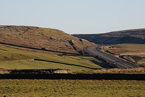
Victorian railway engineers followed the natural course of river valleys, which not only offered smoother gradients but made it easier to avoid troublesome hills. In this case, the deep valley also offered extra protection from the worst of the weather.
Such thoughtful engineering is in marked contrast to the A66 which strikes out optimistically over wild open moorland, largely because the A66 follows the established former Roman road built, as so many were, in a straight line.
Proceeding westwards there continue to be some habitations, but only on the left hand valley side of the road. The Coach and Horses sign indicates a former coaching stop and there are a couple of houses bearing the name Spital, which were at one time hospitals of some kind. These properties have narrow strips of grazing land running down to the old railway line and river.
If visibility is good, it is worth looking out, on the southern horizon, for a distant sighting of the Tan Hill Inn, England’s highest pub. In an age when pub closures are increasing, it is rather remarkable that this remote and isolated establishment has survived and is now more popular than ever.
Beyond the last building on the left, just past another small layby, the A66 enters an area of surface discontinuity, notably with a low embankment running parallel to the road and only a few yards away on the left.
This is the southern outer wall of a former Roman fort, which was placed strategically on the highest ground to offer good defensive visibility in both directions. From the embankment there is an impressive view towards river and railway, and the valley side is strewn with a large expanse of exposed rocks and boulders – hence Stainmore’s the original name, Stonemoor.
This is one of three major forts which were built to protect the trans-Pennine Roman road. Others are at Greta Bridge, behind the Morritt Arms, and at Bowes in the field where the castle keep is located. Bowes Castle, and other castles at Brough and Appleby, are reminders that defence of the Stainmore crossing remained important long after the Romans had left.
From the summit fort, the A66 starts its descent towards the Eden Valley. We are now in Cumbria and there are popular stops for HGV drivers on both sides of the carriageway. For a short distance the A66 runs almost parallel to the old railway trackbed, just beyond a large replica sign marking the old railway summit at 1,370ft.
The A66 abruptly veers right, under steep hard sandstone cliffs and heads downhill to Brough.
The journey until now has been almost directly westwards. Now the A66 shifts to a north-westerly direction, towards Penrith.
The old Roman road persisted on a rather higher route directly along the hillside. This offered the opportunity to build another defensive position which guarded the approach from the Eden Valley. The ramparts and embankments of this small fort can still be traced high up on the hillside, best observed when travelling from west to east.
Finally, as the A66 sweeps around to the north west, it is worth looking out to the left to see the old Stainmore railway line heading along the hillside. There are pronounced railway cuttings and a small road bridge, in fact rather more observable railway engineering here than anywhere on the journey over the Pennines.
Meanwhile, the views towards the Lake District are majestic. To the south, is the prominent Wild Boar Fell and the shapely Howgill Fells, amidst the lovely scenery of the Eden Valley.
This completes our traverse of the Pennines over Stainmore. The long chain of hills, which begins on the outskirts of Ashbourne, in Derbyshire, stretches for almost 140 miles up to the Tyne Gap and Hadrian’s Wall.
There are many Pennine road crossings but none as impressive or as historic as the one over Stainmore.


